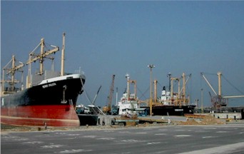
heading

Comparison of Logistics Infrastructure of Countries in ASEAN

port1 road

Infrastructure (airports, seaports, roads, bridges, etc.) are all important to a country in terms of attracting investment and business and to a company when it is time to decide where to locate an investment, build a factory, establish a regional office, etc.  How easy a country is to travel to and the modernity and efficiency of its air and seaports is always something a company and its executives need to consider.  Asia is growing fast and infrastructure in terms of air and seaports is constantly changing.  Below are insights on logistical key installations throughout the region.


Table of Comparison: Logistics Infrastructure of Countries in ASEAN


Port
Airport
Railway
Road
  Cambodia
Poor
Fair
Poor
Poor
  Indonesia
Poor
Fair
Good
Fair
  Laos
Not applicable
Poor
Not applicable
Fair
  Malaysia
Good
Good
Good
Good
  Philliphines
Fair
Fair
Poor
Fair
  Singapore
Good
Good
Good
Good
  Thailand
Good
Good
Good
Good
  Vietnam
Fair
Fair
Fair
Fair
  Burma Poor
Poor Poor Fair
See details below


Details of Logistics Infrastructure for each country:

Cambodia | Indonesia | Laos | Malaysia | Philip
pines | Singapore | Thailand | Vietnam | Burma


for more comparisons, also review:

 Table of Comparison: Infrastructure in Asian Countries (Air, Ground transportation and IT infrastructure)


Cambodia - Logistics Infrastructure *

 
  Port
Port: Poor
  • The three main international ports in Cambodia are: Sihanoukville on the Gulf of Siam, Phnom Penh on the Mekong river, and the provincial port of Koh Kong.
  • Sihaoukvill Port has berth to accommodate large vessels, container terminals and handling facilities, and SEZ, however it needs to solve long waiting times for port calls, and expand cargo-handling capacity to meet the rapidly growing demand.
More on Ports in Cambodia: http://www.business-in-asia.com/cambodia/cambodia_ports.html

Merchant marine:
Total: 544 ships (1000 GRT or over) 1,777,907 GRT/2,529,708 DWT
by type: bulk carrier 41, cargo 443, chemical tanker 11, container 10, livestock carrier 3, passenger/cargo 4, petroleum tanker 9, refrigerated cargo 19, roll on/roll off 2, specialized tanker 1, vehicle carrier 1
Foreign-owned:
407 (Bulgaria 1, Canada 6, China 128, Cyprus 12, Egypt  8, Gabon  1, Greece 8, Hong Kong 15, Indonesia 1, Japan 4, South Korea 23, Latvia 2, Lebanon 6, Nigeria 2, Norway 1, Philippines 1, Russia 105, Singapore 4, Spain 1, Syria 20, Taiwan 2, Turkey 26, UAE 1, Ukraine 17, US 8, Yemen 3) (2006)

 
   Airport
Airport: Fair
Major airport for international logistics is Phnom Penh.  Siem Reap Airpofts see an increasing demand of freight transport and need to expand the handling capacity.

More on Airports in Cambodia: http://www.business-in-asia.com/airports_cambodia.html

Airports: 20 (2006)
Airports - with paved runways:
Total                      : 6
2,438 to 3,047 m      : 2
1,524 to 2,437 m      : 2
914 to 1,523 m         : 2 (2006)
Airports - with unpaved runways:
Total                      : 14
1,524 to 2,437 m      : 2
914 to 1,523 m         : 11
under 914 m            : 1 (2006)

 
  Road
Road: Poor
  • Major roads incluse National Highway No. 1, No. 5 and No. 6, connecting to Vietnam and Thailand. 
  • Road plays an important role in freight transport with a share of 70% against total freight. 
  • Road condition is rather poor and many sections especially around the border are unpaved.
  • No truck can enter Phnom Penh during day time
  • No cargo transfer facility between large and small to medium truck.
Total: 38,257 km
paved: 2,406 km
unpaved: 35,851 km (2004)

 
  Railway
Railway: Poor
  • Railway lines for the north is from Phnom Penh to near the Thai border
  • Railway lines for the south is from Phnom Penh to Sihanoukville
  • Railway line around the Thai border is not practicla.  It requires cargo transfer to trucks when cross border.
  • Low driving speed - no comparative advantage to vehicle transport
Total: 602 km
narrow gauge: 602 km 1.000-m gauge (2005)


Indonesia - Logistics Infrastructure *

 
  Port
Port: Poor
  • Ports and terminals :Banjarmasin, Belawan, Ciwandan, Krueg Geukueh, Palembang, Panjang, Sungai Pakning, Tanjung Perak, Tanjung Priok
  • The majoy ports handling most of Indonesia's export and import cargoes are tanjung Priok, Surabaya, Semarang, Belawan, and Makassar.
  • Operation of Tajung Priok is less efficient compared to to other major ASEAN Ports, with small hanling capacity for vehicle cargo.
  • Terminal handling charges in the country are the highest among major ASEAN ports.
Merchant marine:
Total: 824 ships (1000 GRT or over) 3,773,771 GRT/4,887,614 DWT
by type: bulk carrier 43, cargo 451, chemical tanker 21, container 50, liquefied gas 7, livestock carrier 1, passenger 41, passenger/cargo 58, petroleum tanker 132, refrigerated cargo 2, roll on/roll off 12, specialized tanker 4, vehicle carrier 2
Foreign-owned: 30 (France 1, Germany 1, Japan 3, South Korea 1, Norway 1, Philippines 1, Singapore 17, Switzerland 3, UK 2)
Registered in other countries: 122 (Bahamas 4, Belize 2, Bermuda 1, Cambodia 1, Georgia 1, Hong Kong 4, Liberia 1, Panama 50, Singapore 56, Thailand 1, unknown 1) (2006)


  Airport
Airport: Fair
  • Major international airports are Jakarta, Surabaya, Medan, Semarang, Denpasar, Manado and Palembang. 
  • Because of the insufficient sea and land transport networks, air freight transport is becoming increasing in demand of use.  Also, because of it's relatively lower fares.
More on Airports in Indonesia: http://www.business-in-asia.com/airports_indo.html

Airports: 662 (2006)
Airports - with paved runways:
Total: 159
over 3,047 m: 4
2,438 to 3,047 m: 15
1,524 to 2,437 m: 49
914 to 1,523 m: 49
under 914 m: 42 (2006)
Airports - with unpaved runways:
Total: 503
1,524 to 2,437 m: 6
914 to 1,523 m: 26
under 914 m: 471 (2006)

 
  Road
Road: Fair
  • Roads play most important roles in cargo transportation - approximately 96% of total cargo 
  • Althought the roads have been developed especially for access to may economic centers, traffice congestion in the cities has been a problem.  Especially, heavy traffic congestion in central Jakarta and Surabaya is quite serious
  • Poor accessibility to Tanjung Priok Ports causes stagnated freight transport
Total: 368,360 km
paved: 213,649 km
unpaved: 154,711 km

 
  Railway
Railway: Good
  • Indonesia has four unconnected railway systems: one in Java, and three in Sumatra. 
  • The availability and reliability of service are low, due to inadequate maintenance and lack of spare parts
  • Freight traffic moved by the Java railways consists mostly of petroleum fuel, fertilizer, cement and coal
Total: 6,458 km
narrow gauge: 5,961 km 1.067-m gauge (125 km electrified); 497 km 0.750-m gauge (2005)


Laos - Logistics Infrastructure *

 
  Port
Port: Not applicable

Since Laos is a landlocked country, international ocean trade and ocean transport services depending on neighbouring countries for access to seaports
.
 
Merchant marine:
Total: 1 ship (1000 GRT or over) 2,370 GRT/3,110 DWT
by type: cargo 1 (2006)

 
  Airport
Airport: Poor
  • Major airports are Vientiane and Luang Prabang Airports. 
  • Both airports handle international cargo. 
  • Facilities for cargo are generally insufficient. 
  • Demand of air-cargo transportation is quite low
More on Airports in Laos: http://www.business-in-asia.com/airports_laos.html

Airports: 44 (2006)
Airports - with paved runways:
Total: 9
2,438 to 3,047 m: 2
1,524 to 2,437 m: 4
914 to 1,523 m: 3 (2006)
 
Airports - with unpaved runways:
Total: 35
1,524 to 2,437 m: 1
914 to 1,523 m: 13
under 914 m: 21 (2006)

 
  Road
Road: Fair
  • Asian highway routes totalling 2,298 km pass through Laos and connect to neighbouring countries.
  • Out of the total road network, only 15% of total length was paved.  Cross-border routes, 15% remained un-paved. 
  • Road surface consitions of cross-border routes are generally poor.
  • Recently, the government placed high priority, and the largest share of its public investment, to the development of the road network. 
Total: 31,210 km
paved: 4,494 km
unpaved : 26,716 km

 
  Railway
Railway: Not applicable
  • Currently, the first railway route from the middle of the Friendship Bridge (Thai border) to Tanaleng is under construction.
  •  Several studies also have been undertaken to determne the feasibility of implementing the expansion of railway link.


Malaysia - Logistics Infrastructure *

 
  Port
Ports: Good
  • Ports and terminals : Bintulu, Johor, Labuan, Lahad Datu, Lumut, Miri, George Town (Penang), Port Kelang, Tanjung Pelepas
  • Major ports for international logistics in the Peninsula are Port Klang (central region), Penang Port (northern region and Pasir Gudang / Port of Tanjung Polepes (southern region) 
  • Each port has advanced and sufficient facilities including EDI systems and ample handling capacity to meet present demand.
Merchant marine:
Total: 312 ships (1000 GRT or over) 5,542,727 GRT/7,544,154 DWT
by type: bulk carrier 19, cargo 99, chemical tanker 38, container 48, liquefied gas 27, livestock carrier 1, passenger/cargo 8, petroleum tanker 61, roll on/roll off 5, vehicle carrier 6
foreign-owned: 66 (China 1, Germany 2, Hong Kong 14, Japan 4, South Korea 1, Singapore 44)
registered in other countries : 68 (Bahamas 12, Belize 1, Cayman Islands 1, Mongolia 1, Panama 13, Philippines 1, Singapore 35, US 4) (2006)


  Airport
Airport: Good
  • Major airports for international logistics in the country are Kuala Lumpur Intl. Airport and Penang Intl. Airport. 
  • Both airports have advanced and sufficient facilities including EDI systems and ample landling capacity to meet present demand.
  • These airports presently have sufficient cargo-handling capacity , and the operations of thei handling acilities are also favourable.
More on Airports in Malaysia:
http://www.business-in-asia.com/airports_malaysia.html

Airports: 117 (2006) 
Airports - with paved runways:
Total: 37
over 3,047 m: 5
2,438 to 3,047 m: 9
1,524 to 2,437 m: 8
914 to 1,523 m: 8
under 914 m: 7 (2006)
Airports - with unpaved runways:
Total: 80
1,524 to 2,437 m: 1
914 to 1,523 m: 7
under 914 m: 72 (2006)
 
 
  Road
Road: Good
  • The North South Expressway as an international logistics bone and its connected sections are well developed with no noticeable bottlenecks.
  • However, since the bypass road is available for Kuala Lumpur and Johor Bharu, traffic congrestion and control are not serious botlenecks for fright transportation.
  • Pavement condition in the country is quite favourable. 
  • The Thailand border is also well developed on the Malaysian side
Total: 98,721 km
paved: 80,280 km (includes 1,821 km of expressways)
unpaved: 18,441 km (2004)

 
  Railway
Railway: Good
  • The share of railway freight volume among the entire domestic freight volume is only 0.5%. 
  • Issues such as inconsistent travel hours, lack of locomotives at the Thailand side still inhibit the railway from playing the major role in cross-border trade.
  • Transportation capacity will not be easily augmente because most sections are still single-track and non-electrivied.
Total: 1,890 km
standard gauge: 57 km 1.435-m gauge (57 km electrified)
narrow gauge : 1,833 km 1.000-m gauge (150 km electrified) (2005)


Philippines - Logistics Infrastructure *

 
  Port
Port: Fair
  • Ports and terminals : Cagayan de Oro, Cebu, Davao, Iligan, Iloilo, Manila, Suriga
  • Major ports for international logistics are the Manila Port (North and South harbours), MICT, and Batangas Port 
  • Manila port does not have sufficient handling capacity against the present demand, causing congestion.
  • Investments have gronw rapidly, especially in teh Batangas area.  some companies have already started exporting by container from Batangas.
Merchant marine:
Total: 403 ships (1000 GRT or over) 4,661,285 GRT/6,426,183 DWT
by type: bulk carrier 82, cargo 115, chemical tanker 13, container 6, liquefied gas 5, livestock carrier 17, passenger 9, passenger/cargo 73, petroleum tanker 42, refrigerated cargo 15, roll on/roll off 13, vehicle carrier 13
foreign-owned: 66 (Greece 5, Hong Kong 3, Japan 26, Malaysia 1, Netherlands 19, Norway 3, UAE 1, US 8)
registered in other countries: 41 (Australia 1, Bahamas 1, Cambodia 1, Cayman Islands 1, Comoros 1, Cyprus 1, Hong Kong 16, Indonesia 1, Panama 13, Singapore 5) (2006)


  Airport
Airport: Fair
  • Major airports for international logistics are Ninoy Agulno International Airport (NAIA), and Cebu International Airport
  • FedEx has relocated its operational hub for Asa-Pacific region from Subic Airport to Guangzhou, in south China
More on Airports in Malaysia:
http://www.business-in-asia.com/airports_philippines.html

Airports: 256 (2006)
Airports - with paved runways:
Total: 83
over 3,047 m: 4
2,438 to 3,047 m: 7
1,524 to 2,437 m: 26
914 to 1,523 m: 36
under 914 m : 10 (2006)
Airports - with unpaved runways:
Total: 173
1,524 to 2,437 m: 5
914 to 1,523 m: 69
under 914 m: 99 (2006)

 
  Road
Road: Fair
  • Major trunk lines are the North and South Luzon Expressways stretching from Manila
  • Pavement ratio still remains around 21%.
  • The South Luzon Expressway is not connected to Batangas (one of the major industrial areas having a large port), leaving a missing link.
  • Traffic regulations on truck entry and by vehicle number plates are enforced in Metro Manila.
Total: 200,037 km
paved: 19,804 km
unpaved : 180,233 km

 
  Railway
Railway: Poor
  • Railway line in service is only for southern part of Luzon (Manila to Legazpi)
  • Operational capacity is quite small
  • Freight railway service has been rarely utilized since it is less popular than vehicle transport
  • The railway company is facing a big loss and unable to respond to its invesment needs
Total: 897 km
narrow gauge: 897 km 1.067-m gauge (492 km are in operation) (2005)


Singapore - Logistics Infrastructure *

 
  Port
Port: Good
  • Ports and terminals : Singapore
  • Singapore Port consists of PSA and Julong Container Terminals.
  • Around 80% of the cargo is transshipped. 
  • Port and cargo handling facilities are modern and their operations are quite efficiant, with advanced EDI systems.
  • Although there is no immediate concern about the capacity, the port authority has continually invested in expanding the port-handling capacity to cope with future demand.
Merchant marine:
Total: 1,063 ships (1000 GRT or over) 31,033,735 GRT/49,715,650 DWT
by type: bulk carrier 155, cargo 87, chemical tanker 136, container
214, liquefied gas 53, livestock carrier 1, passenger/cargo 1, petroleum tanker 353, refrigerated cargo 10, roll on/roll off 2, specialized tanker 11, vehicle carrier 40
foreign-owned: 592 (Australia 7, Bangladesh 1, Belgium 12, China 23,
Denmark 52, Germany 9, Greece 9, Hong Kong 50, India 5, Indonesia 56, Italy 2, Japan 100, South Korea 17, Malaysia 35, Netherlands 2, Norway 90, Philippines 5, Slovenia 1, Sweden 12, Taiwan 59, Thailand 22, UAE 7, UK 9, US 7)
registered in other countries: 285 (Antigua and Barbuda 1, Bahamas 12, Belize 6, Bolivia 3, Cambodia 4, Cayman Islands 10, Cyprus 1, Dominica 9, France 2, Honduras 11, Hong Kong 24, Indonesia 17, Isle of Man 7, North Korea 1, Liberia 28, Malaysia 44, Marshall Islands 6, Mongolia 10, Nigeria 1, Panama 67, Saint Vincent and the Grenadines 5, Thailand 6, Tuvalu 6, US 2, unknown 2) (2006)


  Airport
Airport: Good
  • Changi International Airport is the only airport wih favourable cargo-handling facilities. 
  • Invesmtnet has been made regularly to expand the port-handling capacity in prparation for future demand.
  • Capacity is still sufficient to meet present demand for cargo.
  • The cargo terminal operation is also quite favourable.
More on Airports in Singapore:
http://www.business-in-asia.com/airports_singapore.html

Airports: 9 (2006)
Airports - with paved runways:
Total: 9
over 3,047 m: 2
2,438 to 3,047 m: 1
1,524 to 2,437 m: 4
914 to 1,523 m : 1
under 914 m : 1 (2006)

  Road
Road: Good
  • Road condition is quite favourable.
  • Causeway and the Secon Link are connected to Malaysia.  
  • Traffic congestion is well-managed with traffic monitoring and road pricing schemes.
  • Some degree of waiting for customs clearance and inspection is unavoidable at the border points.
Total: 3,234 km
paved: 3,234 km (includes 150 km of expressways) (2005)

  Railway
Railway: Good
  • No railway service, except for communting lines (railway line is owned by Malaysian Railway)


Thailand - Logistics Infrastructure *

 
  Port
Ports: Good
  • Ports and terminals:  Bangkok, Laem Chabang, Prachuap Port, Si Racha
  • Most containerised cargoes have been trasshipped over Singapore, partly because of te draft limitations that exist in the river port of Bangkok.  Laem Chabang port has begun to receive direct calls in major East-West trade.
More on ports in Thailand:
http://www.business-in-asia.com/thai_ports.htm

Merchant marine:
Total: 400 ships (1000 GRT or over) 2,808,509 GRT/4,317,320
DWT
by type: bulk carrier 60, cargo 145, chemical tanker 14, container 21, liquefied gas 29, passenger 1, passenger/cargo 6, petroleum tanker 91, refrigerated cargo 32, specialized, tanker 1
foreign-owned: 45 (China 1, Egypt 1, Indonesia 1, Japan 4, Norway 30, Singapore 6, UK 2)
registered in other countries: 34 (Bahamas 1, Mongolia 1, Panama 9, Singapore 22, Tuvalu 1) (2006)


   Airport
Airports: Good
  • Major international airports include Suvanabhumi, Chiang Mai, Chiang Rai, Hat Yai, and Phuket. 
  • The new Suvarnabhumi will add 120 parkng bays (currently other airports have 179 bays in total) and can be accesed through the Bangkok - Chon Buri Mortorway.
Link to more information on Thailand Airports: http://www.business-in-asia.com/airports_thailand.html
 
Airports: 108 (2006)
Airports - with paved runways:
Total: 66
over 3,047 m : 8
2,438 to 3,047 m: 11
1,524 to 2,437 m: 22
914 to 1,523 m: 20
under 914 m : 5 (2006)
Airports - with unpaved runways:
Total: 42
1,524 to 2,437 m: 1
914 to 1,523 m: 15
under 914 m : 26 (2006)

 
  Road
Road: Good
  • Road condition as a whole is in favourable consition. 
  • Asian Highway is all completed, connection to neighbouring Burma, Laos, Cambodia, and Malaysia. 
  • More than 60% of all Asian Highway sections meet high standards, with more than 4 lanes.
Total: 57,403 km
Paved: 56,542 km
Unpaved: 861 km

 
  Railway
Railway: Good
  • Railway plays a leeser role in freight transport with a share of 2.1% against total freight. 
  • Two international routes to Malaysia are avaiable through Padang Besar, and Sungai Kolok. 
  • Theere is Heavy congestion between Laem Chabang to Lat Krabang ICD
Total: 4,071 km
narrow gauge: 4,071 km 1.000-m gauge (2005)


Vietnam - Logistics Infrastructure *

 
 Port
Port: Fair
  • Ports and terminals : Hai Phong, Ho Chi Minh City
  • The major ports include Hai Phong in the north and Saigon and Can Tho Ports in teh south.
  • Sincer major ports in the southern area are estuarine ports, large vessels can not use these ports.
  • Major ports have advanced and sufficient facilities including EDI systems and ample hanling capacity against the present demand.
More on Ports in Vietnam:
http://www.business-in-asia.com/ports_in_vietnam.html

Merchant marine:
Total: 267 ships (1000 GRT or over) 1,423,936 GRT/2,191,858 DWT
by type: bulk carrier 23, cargo 202, chemical tanker 4, container 5, liquefied gas 5, petroleum tanker 24, refrigerated cargo 2, roll on/roll off 1, specialized tanker 1
foreign-owned: 1 (Denmark 1)
registered in other countries: 17 (Antigua and Barbuda 1, Honduras 1, Mongolia 8, Panama 4, Saint Vincent and the Grenadines 1, unknown 2) (2006)


  Airport
Airport: Fair
  • Major International airports include Ho Chi Minh City, Hanoi (Tan Son Nhat and Noi Bai) and Danang airports. 
  • The demand for freight transport via air is expected to increase sharply.
More on Airports in Vietnam:
http://www.business-in-asia.com/airports_vietnam.html

Airports: 32 (2006)
Airports - with paved runways:
Total: 26
over 3,047 m: 8
2,438 to 3,047 m: 5
1,524 to 2,437 m: 11
914 to 1,523 m: 2 (2006)
Airports - with unpaved runways:
Total: 6
1,524 to 2,437 m: 2
914 to 1,523 m: 2
under 914 m: 2 (2006)

 
 Road
Road: Fair
 
Total: 222,179 km
paved: 42,167 km
unpaved: 180,012 km

  Railway
Railway: Fair
  • Two international routes to China are available from hanoi through Lao Cai and Dong Dan without cargo transfer.
  • Higher utilization of Lao Cai to Hanoi section: unable to respond to the increasing demand and future requirements for cargo trnsfer at the China border due to change of gauge width.
Total: 2,600 km
standard gauge: 178 km 1.435-m gauge
narrow gauge : 2,169 km 1.000-m gauge


Burma - Logistics Infrastructure *

 
  Port
Ports: Poor
  • Ports and terminals : Moulmein, Rangoon, Sittwe
  • The major port for nternational logistics is Yangon Port
  • Cargo-handling facilities are obsolete, and capacity is also limited.  due to sandbanks, there are many ship entr restrictions
  • For hundreds of years, inland water tansporta has played and important role in logistics
Merchant marine:
Tota: 34 ships (1000 GRT or over) 402,699 GRT/620,642 DWT
by type: bulk carrier 8, cargo 20, passenger 2, passenger/cargo 3, specialized tanker 1
foreign-owned: 9 (Germany 5, Japan 4) (2006)


  Airport
Airport: poor
  • Major airports for international logistics include Yangon International Airport, but the role and presence of air transport is quite limited.
  • Cargo-handling facilities are obsolete, and capacity is also limited.
Airports: 85 (2006)
Airports - with paved runways:
Total: 21
over 3,047 m: 8
2,438 to 3,047 m: 7
1,524 to 2,437 m: 4
914 to 1,523 m: 1
under 914 m: 1 (2006) 
Airports - with unpaved runways:
Total: 64
over 3,047 m: 1
1,524 to 2,437 m: 13
914 to 1,523 m: 18
under 914 m: 32 (2006)

 
  Road
Road: Poor
  • Asian Highway (4,543 km) connects to neighbouring countries, but more than 70% of it is lower-class and narrow
  • Road sections around the border that is important for international loistics have not been developed.  There are many river divided and missing sections.
  • Dependency on river transport and railway for cargo transportation is high.
  • East-west connection is also weak due to river conditions.
Total: 27,000 km
paved: 3,200 km
unpaved: 23,800 km (2005)


  Railway
Railway: Fair
  • Most section are single-track and all are non-electrified. 
  • Due to road conditions, railway plays an important role in domestic freight transportation with the share of 35%
Total: 3,955 km
narrow gauge : 3,955 km 1.000-m gauge (2005)


* Airports, Ports, Roads, Railways Numbers -Source: CIA The World Fact Book


Google

www www.Business-in-asia.com
Runckel & Associates LogoContact us


Visit our other website: Asia-Art.net

www.Business-in-Asia.com